
Maldives Maps
About Maldives Maps
🗺️ Maldives Map Guide – Discover the Islands, Atolls, Resorts and Airports of the Maldives 🌴
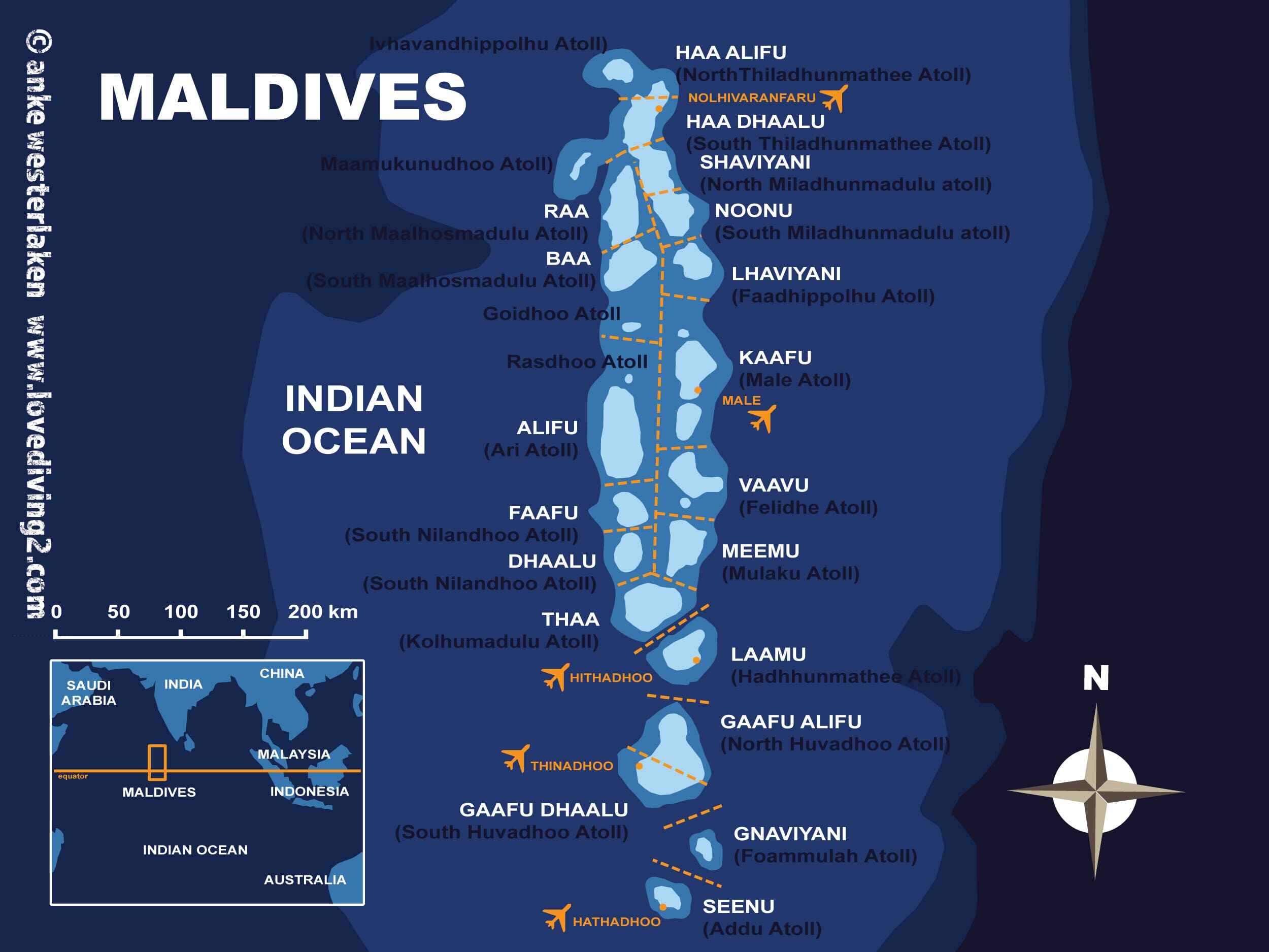
The Maldives is a breathtaking tropical paradise that each year welcomes a great number of tourists with its beautiful lagoons, pristine beaches and luxurious island resorts. However, taking into account the fact that there are approximately 1,200 islands located within the territory of the Maldives, distributed throughout the Indian Ocean, the geographical landscape of this wonderful place may become confusing for first-time visitors to the country.
A Maldives map will be an indispensable aid for all tourists who want to have a fantastic trip to this tropical paradise. Using a proper Maldives map, one can easily locate the most luxurious resorts, the most famous islands, international airports, dive sites and even popular atolls of the Maldives. The Maldives are a country in the Indian Ocean to the south-west of India and Sri Lanka, which includes 26 atolls.
Related Maldives Resorts & Hotels
 Related Resort
North Male Atoll Travel Map
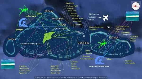
North Male Atoll is the most mapped, most planned, and most researched part of the Maldives - because it is where most first-time visitors land and where most decisions about which resort to book are made. The map above shows the full atoll, from Male city and Velana International Airport in the south to the outer islands in the north, with every resort island marked in position.How to Read This MapThe airport sits on Hulhule Island, immediately adjacent to the capital Male on the southern edge of the atoll. Everything north of that point is resort territory private islands strung along the inner and outer reef system of the atoll, each one accessible by speedboat from the airport jetty.The straight-line distance from the airport to a resort island does not reflect the actual travel time speedboats navigate the lagoon channels rather than the open ocean, so the routes are longer than they appear on the map. A resort that looks close to the airport may take 40 minutes by speedboat due to the route. A resort that looks further away may be faster if the channel is direct.Transfer times are the most useful navigation tool for North Male Atoll more useful than distance, more useful than general position on the map.Resort Positions - North to SouthThe outer reef edge of North Male Atoll runs roughly north to south along the western side of the atoll. The most distant resorts - One & Only Reethi Rah, Gili Lankanfushi, Coco Bodu Hithi sit in the northern and northwestern sections of the atoll. These are 40 to 60 minutes by speedboat or yacht from the airport.The middle section of the atoll - where Baros Maldives, Four Seasons Kuda Huraa, and Huvafen Fushi are positioned is 25 to 40 minutes from the airport.The resorts closest to the airport - Kurumba Maldives, Bandos Maldives, Hulhule Island Hotel sit in the southern section of the atoll within 10 to 20 minutes by speedboat.Key Resorts by Speedboat DurationDurationResort ExamplesPositionChannel Route Type10-20minKurumba, Bandos, Hulhule HotelSouth near airportDirect south20-30minGili Lankanfushi, BarosNW/West midLagoon shortcut30-40minFour Seasons Kuda Huraa, Huvafen Fushi, Coco Bodu HithiMid-centralWestern reef40-60minOne&Only Reethi Rah (yacht)NW outer extremeOuter navigationKey Islands on the MapMale - the capital city on the southern edge of the atoll. Two square kilometres, 200,000 people, ten minutes by ferry from the airport island.Hulhule - the airport island. Velana International Airport, the seaplane terminal, and the domestic terminal are all here.Hulhumale - the reclaimed island connected to Hulhule by the Sinamale Bridge. Guesthouses, mid-range hotels, and the primary overnight option for guests with late arrivals before a seaplane the following morning.Vihamanaafushi - Kurumba Maldives. The oldest resort in the Maldives, ten minutes from the airport.Baros - Baros Maldives. 25 minutes from the airport. Best house reef in the atoll for direct-access snorkelling.Gaaviyan - Gili Lankanfushi. 20 minutes from the airport. Overwater house villas, Mr Friday butler service.Reethi Rah - One & Only Reethi Rah. One of the largest private resort islands in the Maldives. 55 minutes by luxury yacht.Kuredu - Huvafen Fushi. 40 minutes. Underwater spa, small-scale luxury.Fushivaru - Four Seasons Kuda Huraa. 25 minutes. Traditional village architecture, strong family programme.Medhufushi - Coco Bodu Hithi. 40 minutes. Boutique, strong dive programme.Local Islands Visible on the MapThulusdhoo - the surf island. The Cokes break is visible from the beach. Multiple guesthouses, local cafes, surf culture.Himmafushi - quieter local island with traditional lacquerwork and the Jailbreak surf break.Dhiffushi - longest natural beach in the atoll. Minimal tourist infrastructure.Guraidhoo - southernmost local island in North Male Atoll, accessible by public ferry from Male.Map Section InsightsMap SectionTransfer RangeExample Islands/ResortsPro TipsNorthern40-60minReethi Rah, Gili, CocoYacht for luxury, reef edgeMid25-40minBaros (house reef king), Four SeasonsFamily + dive balanceSouthern10-20minKurumba (1972 pioneer)Late arrivals, valueLocalFerry accessThulusdhoo (Cokes surf)Public ferries from MaleUsing the Map for Transfer PlanningWhen comparing resorts in North Male Atoll, position on the map tells you the general direction northern outer reef, inner lagoon, southern section but the specific speedboat route determines the actual transfer time. Resorts on the outer western reef edge typically have longer routes than inner lagoon properties at the same map distance from the airport.Every resort in North Male Atoll uses speedboat transfer. No seaplane is required for any property in this atoll. Transfers operate at any hour there are no daylight restrictions. A late-night international arrival at Velana International Airport can still reach any North Male Atoll resort the same evening.
 Related Resort
South Male Atoll Map
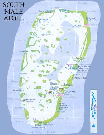
South Male Atoll sits directly south of the capital, separated from North Male Atoll by the channel that runs through the centre of the Maldivian island group. The map above shows the full southern atoll from the properties closest to the airport in the north to the further islands in the southern section, including Kandooma and the surf break it is known for.Reading the MapSouth Male Atoll is smaller in resort density than North Male Atoll. Fewer properties, more space between them, and a quieter general character that the map reflects in the wider gaps between resort islands. The atoll runs north to south with the main resort concentration in the northern section, closest to the airport channel crossing.The airport sits in the adjacent North Male Atoll South Male Atoll resorts are reached by speedboat that crosses the channel between the two atolls. Transfer times are comparable to the equivalent distances within North Male Atoll, though the channel crossing adds a few minutes to any journey.Resort Positions on the MapVelassaru is the closest adults-only luxury resort to the airport in the entire Maldives positioned in the northern section of South Male Atoll, 20 minutes from the airport by speedboat.Adaaran Prestige Vadoo sits in the northern section of the atoll, 20 minutes from the airport. The only all-overwater-villa resort in central atoll range at this price point.OZEN Reserve Bolifushi is also in the northern section ultra-luxury all-inclusive, short speedboat from the airport.Cocoa Island by COMO sits approximately 35 minutes from the airport in the mid-atoll section. The dhoni-shaped overwater villas are visible from the map as a distinctive cluster.Anantara Veli and Anantara Naladhu sit adjacent to each other in the mid-section of the atoll the adults-only and family properties positioned side by side for mixed-age groups who want to stay near each other.Biyadhoo Island Resort is in the southern section, approximately 35 minutes from the airport. The best house reef of any budget resort in the atoll.Holiday Inn Resort Kandooma is the furthest south of the main resort cluster positioned adjacent to the Kandooma surf break on the outer reef edge. Approximately 45 minutes from the airport.DurationResort/PropertyPositionSignature20minVelassaru (Adults-Only)NorthernClosest couples luxury20minAdaaran Prestige VadooNorthernAll-overwater value25minOZEN Reserve BolifushiNorthernUltra-luxury AI35minCocoa Island by COMOMidDhoni overwater design35minAnantara Veli/NaladhuMid adjacentAdults/family pairing35minBiyadhoo IslandSouthernBudget house reef45minHoliday Inn KandoomaSouthern reefSurf break adjacentKey Features on the MapFeaturePositionSeason/DetailsManta PointSouthern reefYear-round cleaning stationKandooma BreakOuter reef (Kandooma)Left-hand, May-Oct swellGurus/Twin PeaksEastern reefLeft/right, intermediateGuraidhoo LocalNorth edgeFerry-accessible cultureUsing the Map for Transfer PlanningSouth Male Atoll speedboat transfers from the airport range from 20 minutes for the closest northern properties to approximately 45 minutes for Kandooma at the southern end. All transfers use speedboats no seaplane is required for any South Male Atoll property. Transfers operate at any hour with no daylight restriction.For guests arriving late on international flights, South Male Atoll is as accessible as North Male Atoll the speedboat crossing between the atolls adds no meaningful constraint.
 Related Resort
Ari (Alifu) Atoll Map
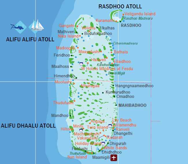
Ari Atoll runs north to south North Ari Atoll (Alifu Alifu) in the upper section, South Ari Atoll (Alifu Dhaalu) in the lower and the map above shows both halves together as the single atoll complex they are geographically. The distance from top to bottom is significant. A resort in North Ari Atoll and a resort in South Ari Atoll are meaningfully far apart, even though they share an administrative name.This matters when using the map to compare transfer options.The Whale Shark Zone on the MapThe South Ari Atoll whale shark zone is not a single marked point it is a broad area covering the central and southern waters of Alifu Dhaalu where the resident whale shark population feeds. The zone extends across multiple kilometres of open water. Resort excursion boats from South Ari Atoll properties cover this area daily.Any resort positioned in the southern section of the Ari Atoll map Conrad Maldives Rangali Island, LUX* South Ari Atoll, Constance Moofushi, Sun Siyam Iru Veli sits within the whale shark zone. The daily excursion reaches the feeding areas in a short boat ride from these resorts.Resorts in North Ari Atoll W Maldives, Ananea Madivaru can run whale shark excursions south but the journey is longer. For guests whose primary purpose is the whale shark encounter, South Ari Atoll positioning on the map is the relevant factor.North vs South Ari Key DifferencesFactorNorth Ari (Alifu Alifu)South Ari (Alifu Dhaalu)Transfer25-30min seaplane30-40min seaplane OR Maamigili domestic (25min + boat)Whale SharksLonger excursions southResident zone (daily short boat)Signature DiveMaaya Thila (northern boundary)Channel pelagicsFlagship ResortsW Maldives, Ananea MadivaruConrad Rangali, LUX* South AriMaamigili Airport on the MapMaamigili Airport Villa International Airport, IATA VAM sits on the southeastern edge of South Ari Atoll. The airport is visible on the map as the domestic aviation hub for the southern section of the atoll. Resorts near Maamigili can be reached by a 25-minute domestic flight from Velana International Airport followed by a short speedboat avoiding the seaplane entirely.For guests comparing transfer options between seaplane and domestic flight, the map shows which resorts sit close enough to Maamigili to make the domestic flight route practical.Key Resort PositionsNorth Ari Atoll (Alifu Alifu) - upper section of the map:W Maldives, Ananea Madivaru, Constance Halaveli, Kuramathi (technically Rasdhoo Atoll, visible at the northeastern edge).South Ari Atoll (Alifu Dhaalu) - lower section of the map:Conrad Maldives Rangali Island, LUX* South Ari Atoll, Constance Moofushi, Sun Siyam Iru Veli, Diamonds Thudufushi.Maaya Thila - marked on the map at the northern boundary between Rasdhoo and North Ari Atoll. One of the finest dive sites in the Indian Ocean. Most North Ari Atoll dive centres run excursions here.Map SectionKey ResortsTransfer OptionExcursion AccessNorth AriW Maldives, Ananea Madivaru, Constance Halaveli25min seaplaneMaaya Thila (local)South AriConrad Rangali (Ithaa), LUX*, Moofushi, Iru Veli30-40min seaplane OR Maamigili domesticWhale shark zone (daily)NE EdgeKuramathi (Rasdhoo adjacent)25min seaplaneHammerheads nearbyTransfer Times from MaleSeaplane from Velana International Airport to North Ari Atoll: approximately 25 to 30 minutes.Seaplane to South Ari Atoll: approximately 30 to 40 minutes.Domestic flight to Maamigili Airport: approximately 25 minutes, then short speedboat.All seaplane transfers operate daylight hours only. The Maamigili domestic flight alternative avoids this restriction for South Ari Atoll resorts near the airport.
 Related Resort
Baa Atoll Map
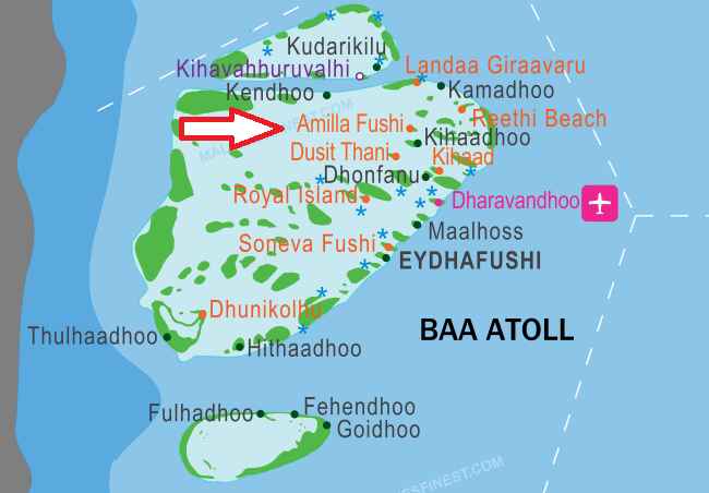
The Baa Atoll map has one feature that every visitor looks for first: Hanifaru Bay. The most celebrated manta ray feeding site in the world sits on the southeastern edge of the atoll, and every resort in Baa Atoll positions its excursion programme around reaching it. Understanding where each resort sits on the map relative to Hanifaru Bay is one of the most practical uses of this guide.Where Hanifaru Bay Is on the MapHanifaru Bay is on the southeastern edge of Baa Atoll visible on the map as the small, protected bay just inside the reef. It is within the UNESCO Biosphere Reserve boundary that covers the entire atoll.The resorts closest to Hanifaru Bay on the map are Anantara Kihavah and Four Seasons Landaa Giravaaru both positioned in the southeastern section of the atoll with excursion boats reaching Hanifaru in approximately 15 to 25 minutes.Vakkaru Maldives and Milaidhoo Island sit in the same southeastern region and have similarly short excursion runs to the bay.Soneva Fushi, in the western section of the atoll, is further from Hanifaru the excursion takes approximately 30 to 40 minutes. Still practical, but the additional distance is visible on the map.Dharavandhoo island with its domestic airport sits in the northeastern corner of the atoll the key landmark for guests using the domestic flight plus speedboat transfer alternative.Resort Distance to Hanifaru BaySectionResortBoat Time to BayTransfer ModeSoutheastAnantara Kihavah15-25min25-35min seaplaneSoutheastFour Seasons Landaa15-25min25-35min seaplaneSoutheastVakkaru, Milaidhoo20-30min25-35min seaplaneWesternSoneva Fushi30-40min25-35min seaplaneWesternThe Nautilus35-45min25-35min seaplaneNorthernClub Med Finolhu40min+Dharavandhoo optionResort PositionsSoutheastern section (closest to Hanifaru Bay):Anantara Kihavah, Four Seasons Landaa Giravaaru, Milaidhoo Island Maldives, Vakkaru Maldives.Western section (furthest from Hanifaru, closer to open ocean):Soneva Fushi, The Nautilus Maldives, Finolhu Baa Atoll.Northern section:Club Med Finolhu.Transfer Options on the MapSeaplane from Velana International Airport: 25 to 35 minutes to most Baa Atoll resorts. The standard method. Daylight only.Domestic flight to Dharavandhoo Airport (marked in the northeastern section of the map) followed by a speedboat to the resort: approximately 30 minutes flying plus 15 to 45 minutes speedboat depending on which resort. This route avoids the seaplane daylight restriction and the 20kg luggage limit. For guests arriving at Malé after approximately 3pm, the domestic flight to Dharavandhoo the following morning is often the more practical option.The UNESCO Biosphere Reserve BoundaryThe entire Baa Atoll sits within the UNESCO Biosphere Reserve boundary. All resort operations within the atoll excursion protocols, anchor restrictions, visitor numbers at Hanifaru Bay are governed by the reserve regulations. The strict visitor cap at Hanifaru Bay is part of this slots are limited per session, resorts book in advance, and the USD 30 per person entry fee goes directly to the Baa Atoll Conservation Fund.Seaplane vs Domestic FlightFactorSeaplaneDharavandhoo DomesticTotal Time25-35min direct30min flight + 15-45min boatLuggage20kg strict limitNo restrictionsLate ArrivalDaylight only (6AM-4PM)24/7 flexibilityCostPremiumBudget-friendlyLocal Islands on the MapEydhafushi - the capital of Baa Atoll, largest inhabited island, local market, traditional fishing community.Dharavandhoo - domestic airport island and growing guesthouse hub for independent travellers seeking Hanifaru Bay access at budget prices.Thulhaadhoo - the lacquerwork island. The last remaining traditional laajehun artisan families in the Maldives operate here. Worth a day trip for guests interested in Maldivian craft culture.
 Related Resort
Raa Atoll Map Maldives
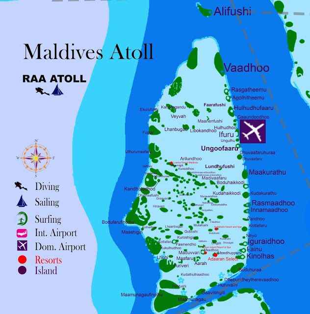
Raa Atoll is the first of the northern atolls that most resort guests encounter far enough from Male to feel meaningfully remote, accessible enough via Ifuru Airport to reach in a manageable total journey time. The map above shows the full atoll, from the southern boundary with Baa Atoll to the northern edge adjacent to Noonu Atoll, with resort positions, the domestic airport, and the inhabited island communities marked across the reef structure.Ifuru Airport on the MapIfuru Airport (IATA: IFU) sits on the eastern edge of Raa Atoll and is the key infrastructure point on the map for planning any Raa Atoll visit. Domestic flights from Velana International Airport take approximately 30 minutes. A speedboat from Ifuru reaches most resort islands in the atoll in 15 to 45 minutes.The airport is visible on the map in the eastern section of the atoll. Resorts on the eastern side are closest to Ifuru and have the shortest speedboat connections. Resorts on the western reef edge are further from the airport but face the open ocean for better sunset orientation and more direct exposure to the atoll's western dive sites.Resort PositionsMovenpick Resort Kuredhivaru sits in the central section of the atoll a mid-distance speedboat from Ifuru, positioned on a private island with good lagoon access on multiple sides.Dhigali Maldives is in the northern section, with an activity-focused programme and strong all-inclusive options. The position on the map reflects the atoll's wider northern section where boat access to multiple dive sites is practical.Furaveri Maldives is positioned in the central-northern area with overwater villa categories and a comprehensive all-inclusive option.Amilla Maldives sits at the Baa-Raa border visible on the southern edge of the Raa Atoll map where it meets Baa Atoll. The border position gives the resort access to both atoll dive systems.Resort Positions + TimesSectionResortSpeedboat from IfuruKey FeatureCentralMovenpick Kuredhivaru25-35minLagoon accessNorthDhigali Maldives35-45minAll-inclusive activitiesCentral-NorthFuraveri Maldives30-40minOverwater AISouth BorderAmilla Maldives15-25minBaa-Raa dive crossoverLocal Islands on the MapUngoofaaru the capital of Raa Atoll, visible in the central-western section. Traditional fishing community with a boat-building history. Local market and public ferry connections.Rasgetheemu a local island known for traditional handicrafts, visible in the northern section of the map.The inhabited islands of Raa Atoll are distributed across the atoll with more geographic spread than the guesthouse-focused local islands of the central atolls. Visiting them requires planning around ferry schedules rather than the on-demand speedboat access available from the central atoll resorts.Understanding Raa Atoll's PositionThe map shows Raa Atoll between Baa Atoll to the south and Noonu Atoll to the north. The dry season manta rays that aggregate at Baa Atoll's Hanifaru Bay from May through October move into Raa Atoll waters during the dry season months from November through April. The Raa Atoll map position above Baa explains this migration as Hanifaru Bay activity decreases, the mantas move north into the adjacent atoll system.Seasonal Shifts Raa AtollMonsoonSitesPeak MonthsNE DrySola Corner (west)Dec-AprSW WetEastern sitesMay-NovYear-RoundMultiple cleaning stationsAug-Nov peak
 Related Resort
Gaafu Atoll Map Maldives
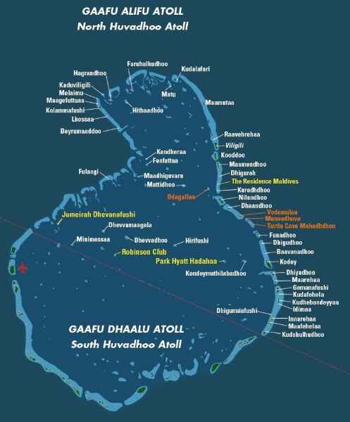
The Gaafu Atoll map covers an enormous area. Huvadhoo the historical name for the combined Gaafu Alifu and Gaafu Dhaalu atolls is the second largest atoll in the Maldives and one of the ten largest natural atolls in the world. The lagoon it encloses covers approximately 3,200 square kilometres. Mapping the full atoll in a single view requires a scale that makes the distance between its northern and southern edges clearly apparent.The map is divided administratively into two sections. Gaafu Alifu (North Huvadhoo) occupies the upper portion, with Villingili as its capital and Kooddoo Airport as its domestic hub. Gaafu Dhaalu (South Huvadhoo) occupies the lower portion, with Thinadhoo as its capital and Kaadedhdhoo Airport as its hub.The Two AirportsKooddoo Airport (IATA: GKK) sits in the Gaafu Alifu section visible on the map in the northern portion of the atoll complex. Domestic flights from Velana International Airport take approximately 55 minutes. This is the access point for resorts and inhabited islands in the northern half of Huvadhoo.Kaadedhdhoo Airport (IATA: KDM) sits in the Gaafu Dhaalu section visible in the southern portion. Same approximate flight time from Malé. This is the access point for resorts and islands in the southern half, including Ayada Maldives.The choice of which airport to use depends entirely on the position of the specific resort on the map. Some properties are equidistant and can use either airport depending on availability and scheduling.Resort Positions + TransfersSectionResort/Key PropertyAirport (55min flight)Boat TimeSignatureGaafu Alifu (North)Mercure KooddooKooddoo GKK0.1mi/5minAdults-only boutiqueGaafu AlifuResidence DhigurahKooddoo GKK20-30minAll-villa beach/overwaterGaafu AlifuPullman MaamutaaKooddoo GKK25-35minLarge AI scaleGaafu AlifuHalcyon Private Isles (2025)Kooddoo GKK30minMarriott luxuryGaafu Dhaalu (South)Ayada MaldivesKaadedhdhoo KDM50min (or Maavarulu 15-25min)Most remote 5-starGaafu DhaaluNH Collection HavoddaKDM15minTotal 75min from VelanaThe One and a Half Degree ChannelThe One and a Half Degree Channel is visible on the map as the broad open water gap between the southern Maldivian central atolls and the northern boundary of Gaafu Alifu Atoll. This is the oceanographic feature that defines the quality of the diving throughout Huvadhoo deep, nutrient-rich Indian Ocean water forced through this passage feeds the reef systems of both atolls. The channel is the widest in the Maldivian island chain and a recognised liveaboard diving route.The Huvadhoo Kandu visible on the northern boundary of Gaafu Alifu on the map is the channel entry point for liveaboards approaching from the north. The channel walls and current conditions here produce some of the finest drift diving in the southern Maldives.Resort PositionsAyada Maldives - southern rim of Gaafu Dhaalu Atoll, visible in the southernmost section of the map. The most remote position of any five-star resort in the Maldives relative to Male. The isolation is the point the lagoon quality and reef condition here reflect the absence of heavy tourism development.Pullman Maldives Maamutaa - Gaafu Alifu section, northern half of the map. Large resort with strong all-inclusive options.The Residence Maldives at Dhigurah - visible in the Gaafu Alifu section. All-villa property with beach and overwater categories.Halcyon Private Isles Maldives - opened November 2025, Gaafu Alifu section, Marriott Autograph Collection.Local Islands on the MapThinadhoo - the largest inhabited island in the southern Maldives outside Addu City. Visible as one of the major islands in the Gaafu Dhaalu section. Capital of Gaafu Dhaalu Atoll with a port, local market, and government facilities.Villingili - capital of Gaafu Alifu, visible in the northern section.Dhigurah - a local inhabited island in Gaafu Alifu with a developed guesthouse sector, a long natural beach, and whale shark snorkelling excursions.Gaadhu - visible in the Gaafu Alifu section. The island where the finest woven Thundu Kunaa mats in the Maldives are produced.