
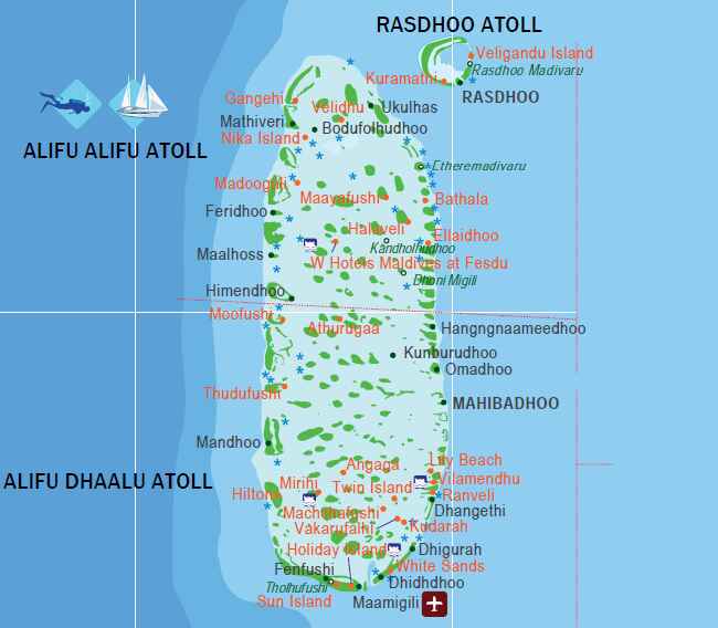
Ari Atoll Map
Ari Atoll runs north to south North Ari Atoll (Alifu Alifu) in the upper section, South Ari Atoll (Alifu Dhaalu) in the lower and the map above shows both halves together as the single atoll complex they are geographically. The distance from top to bottom is significant. A resort in North Ari Atoll and a resort in South Ari Atoll are meaningfully far apart, even though they share an administrative name.
This matters when using the map to compare transfer options.
The Whale Shark Zone on the Map
The South Ari Atoll whale shark zone is not a single marked point it is a broad area covering the central and southern waters of Alifu Dhaalu where the resident whale shark population feeds. The zone extends across multiple kilometres of open water. Resort excursion boats from South Ari Atoll properties cover this area daily.
Any resort positioned in the southern section of the Ari Atoll map Conrad Maldives Rangali Island, LUX* South Ari Atoll, Constance Moofushi, Sun Siyam Iru Veli sits within the whale shark zone. The daily excursion reaches the feeding areas in a short boat ride from these resorts.
Resorts in North Ari Atoll W Maldives, Ananea Madivaru can run whale shark excursions south but the journey is longer. For guests whose primary purpose is the whale shark encounter, South Ari Atoll positioning on the map is the relevant factor.
North vs South Ari Key Differences
Maamigili Airport on the Map
Maamigili Airport Villa International Airport, IATA VAM sits on the southeastern edge of South Ari Atoll. The airport is visible on the map as the domestic aviation hub for the southern section of the atoll. Resorts near Maamigili can be reached by a 25-minute domestic flight from Velana International Airport followed by a short speedboat avoiding the seaplane entirely.
For guests comparing transfer options between seaplane and domestic flight, the map shows which resorts sit close enough to Maamigili to make the domestic flight route practical.
Key Resort Positions
North Ari Atoll (Alifu Alifu) - upper section of the map:
W Maldives, Ananea Madivaru, Constance Halaveli, Kuramathi (technically Rasdhoo Atoll, visible at the northeastern edge).
South Ari Atoll (Alifu Dhaalu) - lower section of the map:
Conrad Maldives Rangali Island, LUX* South Ari Atoll, Constance Moofushi, Sun Siyam Iru Veli, Diamonds Thudufushi.
Maaya Thila - marked on the map at the northern boundary between Rasdhoo and North Ari Atoll. One of the finest dive sites in the Indian Ocean. Most North Ari Atoll dive centres run excursions here.
| Map Section | Key Resorts | Transfer Option | Excursion Access |
|---|---|---|---|
| North Ari | W Maldives, Ananea Madivaru, Constance Halaveli | 25min seaplane | Maaya Thila (local) |
| South Ari | Conrad Rangali (Ithaa), LUX*, Moofushi, Iru Veli | 30-40min seaplane OR Maamigili domestic | Whale shark zone (daily) |
| NE Edge | Kuramathi (Rasdhoo adjacent) | 25min seaplane | Hammerheads nearby |
Transfer Times from Male
Seaplane from Velana International Airport to North Ari Atoll: approximately 25 to 30 minutes.
Seaplane to South Ari Atoll: approximately 30 to 40 minutes.
Domestic flight to Maamigili Airport: approximately 25 minutes, then short speedboat.
All seaplane transfers operate daylight hours only. The Maamigili domestic flight alternative avoids this restriction for South Ari Atoll resorts near the airport.